A NASA satellite has captured a dramatic image of the entire Earth outlined against the darkness of space, reminiscent of the famous "Blue Marble" photo taken on the Apollo 17 mission.
The Apollo photo was taken from a distance of 28,000 miles; the new Earth selfie was snapped from a million miles away by a camera/telescope on NASA's Deep Space Climate Observatory (DSCOVR) satellite.
The image was created using 10 images taken by the 4-megapixel Earth Polychromatic Imaging Camera (EPIC), with each image taken using a separate filter from near infrared through ultraviolet frequencies.
The range of filters produces a variety of images for scientific study, although the release color photo required only the red, blue and green channel image, NASA explained in a release.
"The high quality of the EPIC images exceeded all of our expectations in resolution," says Dscovr project scientist Adam Szabo. "The images clearly show desert sand structures, river systems and complex cloud patterns. There will be a huge wealth of new data for scientists to explore."
Taken only July 6, the image is centered on North and Central America.
The main mission of Dscovr, a joint mission by NASA, the National Oceanic and Atmospheric Administration and the U.S. Air Force, is to monitor solar winds to help provide data allowing scientists to make forecasts about space weather such as electromagnetic solar storms that can effect satellite communications and terrestrial power grids.
The satellite, launched in February, reached its final destination point a million miles from Earth in early June.
It now orbits at a point astronomers refer to as L1, or a Lagrange point, where the gravitational attraction of the Earth and the sun work on the spacecraft to keep it in a stationary location relative to the two bodies.
The satellite will continue to take photos of the Earth every day in addition to its main space weather science tasks, and NASA said it would set up a dedicated web page to showcase the images.
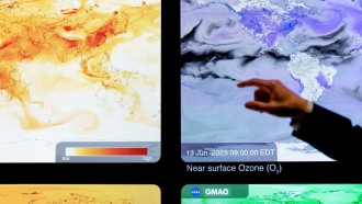
The images will allow researchers to monitor ozone and pollution levels in our atmosphere in addition to cloud height and vegetation properties on Earth, NASA officials say.
"This first DSCOVR image of our planet demonstrates the unique and important benefits of Earth observation from space," says NASA Administrator Charlie Bolden. "As a former astronaut who's been privileged to view the Earth from orbit, I want everyone to be able to see and appreciate our planet as an integrated, interacting system."