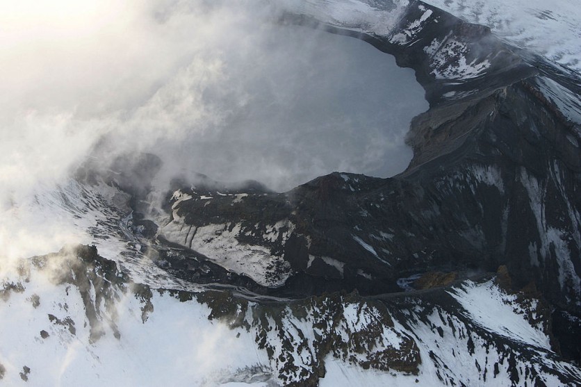
An astronaut onboard the International Space Station (ISS) took a photo of Mount Ruapehu in New Zealand, as reported by SciTechDaily. The photo offers a straight-down view of the mountain.
Mount Ruapehu
Mount Ruapehu is a stratovolcano and is the tallest mountain on the North Island. A stratovolcano is a conical volcano made up of layers of hardened lava, volcanic ash, and pumice.
The photo shows the Crater Lake that holds all the clues to what's going on in the volcano. Crater Lake is heated by a hydrothermal system that remains warm all year round and is highly acidic. Prolonged temperature spikes in the lake may be a sign of impending volcanic activity. You can view the photos here.
Mount Ruapehu has been dormant since 2011, but recently, it started to show signs of unrest again as volcanologists started to detect moderate tremors in March 2022. They issued an alert about heightened volcanic activity and took periodic lake temperature measurements and sulfur dioxide emission samples to track the changes.
During this time, volcanologists detected magmatic intrusion beneath the volcano, which suggested that magma was slowly rising under the volcano, but it stopped. As a result, scientists suggested that the eruption may have increased within the Crater Lake basin.
Recently in July, the temperatures and emissions dropped to a level that is enough to lower the volcanic alert level.
Also Read: Looming Eruption Prompts Warning To Stay Away From New Zealand's Lord Of The Rings Volcano
Monitoring Mount Ruapehu
Mount Ruapehu sits at a high altitude above sea level, but right now, the high altitude is a hindrance to scientists who want to observe what's going on. The low-resolution satellite images are not enough to tell the team how deep the magma is or if there are signs of unrest in the volcano.
The volcano is one of the most frequently monitored volcanoes on the planet with satellite data, ground-based geodetic monitoring, and other techniques.
On the other hand, the lake is unique because it is a closed body of water that only receives water from rainfall and snow, which allows scientists to measure the temperature of the hydrothermal system. It is also helpful for measuring the emission of sulfur dioxide, which is the first sign of an increase in volcanic activity.
Volcano activity may lead to pyroclastic flows, which are very dangerous. When a volcano becomes active and experiences an eruption, it can produce sudden, intense releases of ash, rock, and gases. The gas and ash are propelled into the air, which then falls back onto the ground as hot ash flows. All of these can lead to debris flows, mudflows, and avalanches, which can cause damage to transport systems, buildings, and the environment.
The photos taken by the ISS are helpful for tracking volcanic activity and alerting people of potential risks.
Related Article: LOOK: Massive Volcano Eruption Seen From Space
This article is owned by Tech Times
Written by April Fowell
ⓒ 2026 TECHTIMES.com All rights reserved. Do not reproduce without permission.


