It won't be pretentious to say January 3, 2023, is a historic date for EOS Data Analytics, a global provider of AI-powered satellite imagery analytics. On this day, SpaceX's Falcon 9 rocket transported EOS SAT-1, the first satellite of the EOS SAT constellation, into a low Earth orbit. The launch took place from the Cape Canaveral Space Force Station in Florida.
Why did the provider of AI-powered satellite imagery analytics decide to have its swarm, and what's unique about it? We met with Andrii Muzychenko, EOS SAT Project Manager at EOS Data Analytics, to find out.
Please tell our readers briefly about EOS SAT.
EOS SAT is a seven-satellite constellation designed for users needing reliable data with properties specifically chosen for solving agriculture-related tasks. The satellites will fly above the sun-illuminated section of the Earth half of the time, which means we'll be able to provide images of high quality - lightning conditions are favorable for that. In scientific words, EOS SAT will follow a sun-synchronous orbit.
(Video: Space.com)
Broadcast recording of the EOS SAT-1 launch.
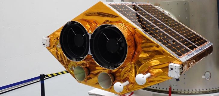
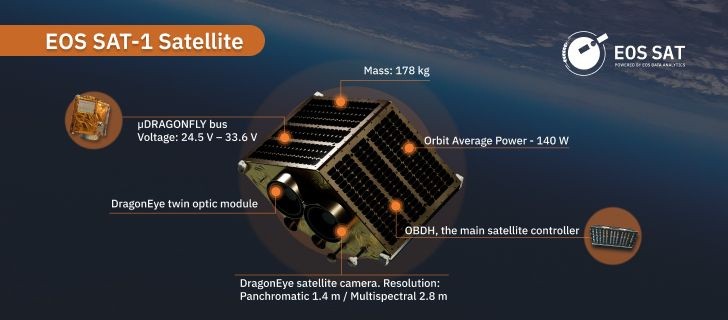
The first satellite we've recently deployed, EOS SAT-1, is orbiting 557.5 kilometers above the planet's surface as we speak. The remaining ones are scheduled for launch during 2023-2025.
The start of the satellite project is the fruit of over 100 people's work, not only EOS Data Analytics staff. Engineers from Dragonfly Aerospace are in charge of manufacturing all seven satellites. They've also developed software for managing data collection and Mission Control Center for EOS SAT-1 and the future swarm. Dragonfly Aerospace is a space imaging systems technology provider.
Colleagues from Space Electric Thruster Systems developed the ion propulsion system for the first satellite. The installation creates thrust to maintain the given parameters of the satellite's orbit, thereby lengthening its lifetime.
These two companies are from the Noosphere group of companies of Dr. Max Polyakov, international space entrepreneur and the founder of EOS Data Analytics.
There are two types of satellites: radar and optical. What about EOS SAT?
All satellites will be optical because, as I said earlier, the constellation will fly above the Earth's surface when it's illuminated by the Sun. Additionally, radar satellites generating SAR data are not suitable for analyzing the state of crops.
What is the purpose of building the satellite constellation?
Our work specifics are that we not only provide customers with data (satellite, weather, soil moisture, crop rotation, field productivity, etc.) but analyze this data so that they can use insights to support their decision-making. So, our R&D department of 60 scientists and 25 Ph.Ds clearly understand their data needs. Sales managers also get requests from prospects; account managers communicate with farmers, agricultural holdings, insurance companies, and banks working with the industry players.
We researched the satellite data market to systematize feedback from EOSDA Crop Monitoring users and define data gaps. The precision agriculture platform has over 950,000 users, so the statistical sample was more than sufficient. Long story short, we concluded the tool has a competitive feature set but lacks unique data. And such data can only be generated by satellites with specific technical characteristics.
Moreover, we wanted to be more independent of third-party providers regarding the frequency of satellite revisits, quality of satellite camera sensors, or a set of spectral bands, and other parameters necessary for working agri tasks. That's when the idea to develop a satellite constellation was born.
What technical characteristics allow the satellite constellation to compare favorably with others?
Let me start with the coverage - the territory satellites monitor every day. This parameter for EOS SAT-1 is nearly 0.8-1 million square kilometers. The six other satellites will cover about 1.3-1.4 million square kilometers. So, once all seven machines are in orbit, EOS SAT will monitor from 8.6 to 9.4 million square kilometers. But that's not the limit. We can reach the coverage to 12 million square kilometers by increasing a satellite's average downlink rate.
Once reaching total capacity, the swarm will cover 100% of countries with the largest areas of farmlands and forestlands; that's 100% of such lands on the planet.
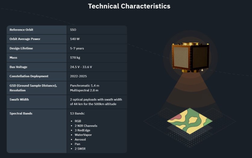
Another critical parameter is the interval in which a satellite or constellation makes an image of the same territory. EOS SAT's revisit period is five to six days, which allows for spotting changes on the surface regularly. Users can request the swarm to visit their field 'out of turn'; in this case, it will return to the area of interest (AOI) within 24 hours. Custom tasking for larger territories (country-level) may take up to four days.
Of course, customers need answers to their questions instead of raw imagery taken by satellite cameras. Having a constellation now allows us to carry out all steps of working with data in-house. The data cycle, from image generation to presenting analytics results within our precision agriculture tool EOSDA Crop Monitoring, is from 16 to 24 hours.
I can't avoid mentioning spectral bands - regions (ranges) of the electromagnetic spectrum in which cameras' sensors detect light energy when making images. The constellation satellites will provide two types of images defending their visibility to the human eye: panchromatic (Red, Green, and Blue) and multispectral.
EOS SAT-1 will have 11 spectral bands:
3 RGB channels for making high-quality color images.
2 NIR (near-infrared) channels for transmitting data in the near-infrared range. These bands are used for detecting chlorophyll levels in plants.
3 RedEdge channels, in which the reflectivity of plant leaves increases dramatically. Specialists use RedEdge images to monitor crop growth dynamics and detect plant diseases caused by pests or fungi.
WaterVapor, Aerosol, and Pan bands for monitoring soil moisture and air humidity (water vapor) and measuring the presence of aerosols (dust, fog, and plant pollen) in the atmosphere.
Satellites starting from EOS SAT-2 will have 13 bands, including two SWIR (short-wave infrared) ones. Images of the unilluminated side of the Earth taken using this band are almost as clear as in the visible spectrum. Water stress detection, crop maturation assessment, and agricultural produce sorting are the everyday use cases for SWIR in farming.
These bands are our main competitive advantage as each is tailored for monitoring farmlands and forest areas. EOS SAT is a unique solution in this case. Of course, one can source imagery from competitors' satellites for agricultural purposes. But these satellites are rarely equipped with the bands we have by default.
How will farmers benefit from using EOS SAT data?
Analysis of data about crop and soil conditions generated by EOS SAT will permit farmers to have a 360-degree view of their fields. That will help them have more control over field operations while optimizing the use of resources (inputs, water, energy, or gasoline) - the core element of precision agriculture. For example, introducing the variable application of fertilizers prevents soil erosion and improves the ecosystem of soil microorganisms. In addition, fewer chemicals end up in waterways.
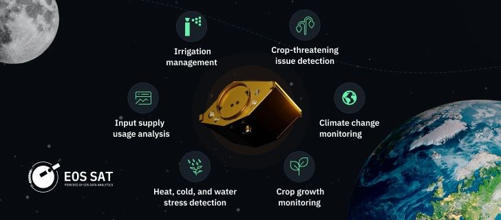
Given the harmful impact of agriculture on the environment, adopting satellite field monitoring and imagery analytics is one of the ways to transition toward sustainable production.
ⓒ 2026 TECHTIMES.com All rights reserved. Do not reproduce without permission.


