
Maps have evolved as technology continues to transform the utility of different media. No longer are they simply sheets of paper that are used as a guide in navigation, to locate the distance between two places, or to visualize the world's many landforms and bodies of water.
Today, maps can show geodata and highlight essential information regarding a specific location, such as population density or an establishment's services. Web mapping platforms include these features and make the results instantly shareable across the internet.
What Are the Benefits of Web Mapping?
Web mapping enables developers to integrate various features and customize the virtual elements of their web maps through mapping software. They can share multiple layers of geographical data, making them more visually appealing to their audience. Maps can be made more interactive and impressive in their design and utility.
A web map can provide essential information in just a few clicks, enabling users to learn directly through its features. People can explore distant terrains, travel virtually through historical landmarks, or simply find the fastest route to arrive at their destination. With the appropriate mapping software, anyone can create and design their web maps to enhance the visualization of information.
Listed below are the top 5 web mapping platforms of 2023:
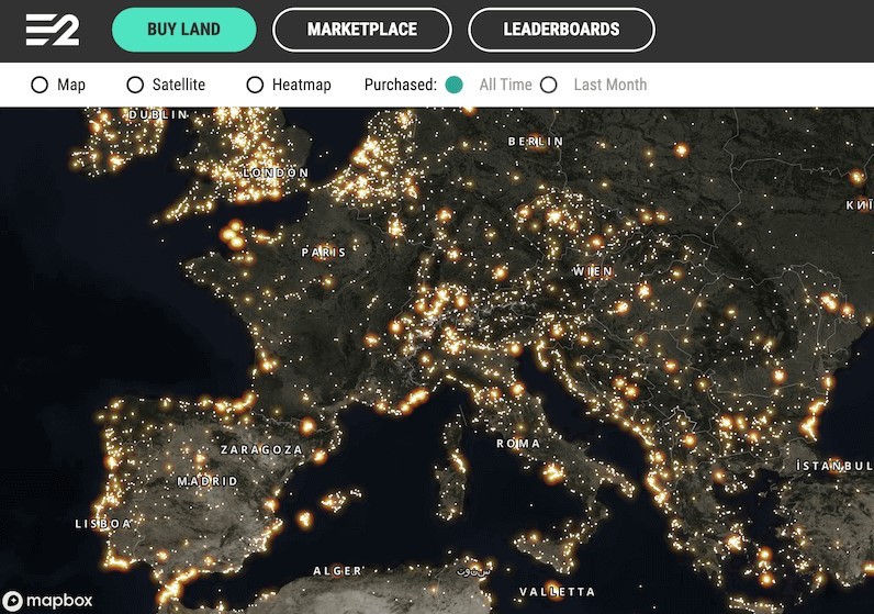
1 MapTiler
Overview
Over 350 million people see MapTiler maps every month; in news articles, weather forecasts, the infotainment systems on airplanes, and many more places. MapTiler has been chosen by thousands of businesses and institutions from all over the world. As a company, MapTiler aims to address the limitations and privacy concerns found in the maps available from other companies. Often, these maps are difficult to customize and simply expensive to integrate into existing web applications.
As mapping software, MapTiler provides web maps that can communicate complex data in a geographical context. There is extensive documentation and code samples to guide development and seamless integration. It also offers flexibility and personalization of web map creation, all at a fair price.
MapTiler provides satellite and street mapping data along with software and online services that allow organizations to transform geodata into visually appealing, customizable, and reliable web maps. The company uses a global infrastructure with over 250 servers on five continents, enabling the fastest possible loading times anywhere on the planet.
Unlike large companies, MapTiler has no intention of selling personal information to advertisers or third parties. It is a pure mapping software intended only to improve the creation of web maps for developers. Even if they are currently smaller in comparison to other large incumbent competitors, the company intends to deliver proper customer support and quality web mapping services at an affordable price.
Many companies like NASA, Siemens, and the BBC have relied on the web mapping platform MapTiler to highlight their core business data in the right geographical context. With its user-friendly interface, complementary map styles, and integrations, anyone can design and develop maps through MapTiler.
Features
Map Customization
The mapping software of MapTiler offers beautiful map styles for a range of different purposes all of which can be customized in a simple yet powerful interface. Anyone can modify its elements to match the brand of their organization. Developers and designers can adjust the colors, fonts, and language to accommodate the needs of their target audience. For businesses, they can choose to highlight their locations above their competitors to gain more geographic visibility.
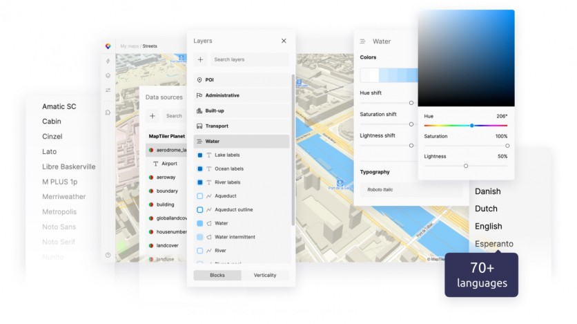
MapTiler currently supports over 70 world languages. Developers can set the language to match the browser settings or the location that the user is logging in from to best serve the audiences, especially consumers located in different regions. It is inclusive, just as it is holistic for map visualization.
Moreover, MapTiler offers more detailed customization of map layers, enabling developers to add fine details or remove them for a more transparent data overlaying. They can choose to highlight the buildings or the roads of cities or hide them from the surface area of the web map.
With its customization tool, MapTiler also enables the addition of customers' geodata that they have uploaded to MapTiler Cloud. Developers can layer their geodata with the existing map style to improve its visual effect. By using the JSON format, they can constantly adjust the map style of their custom web maps.
Maps API
Maps API serves as the building blocks or the foundation for location intelligence. MapTiler provides developers with its maps API for web or mobile applications through the MapTiler Cloud service.
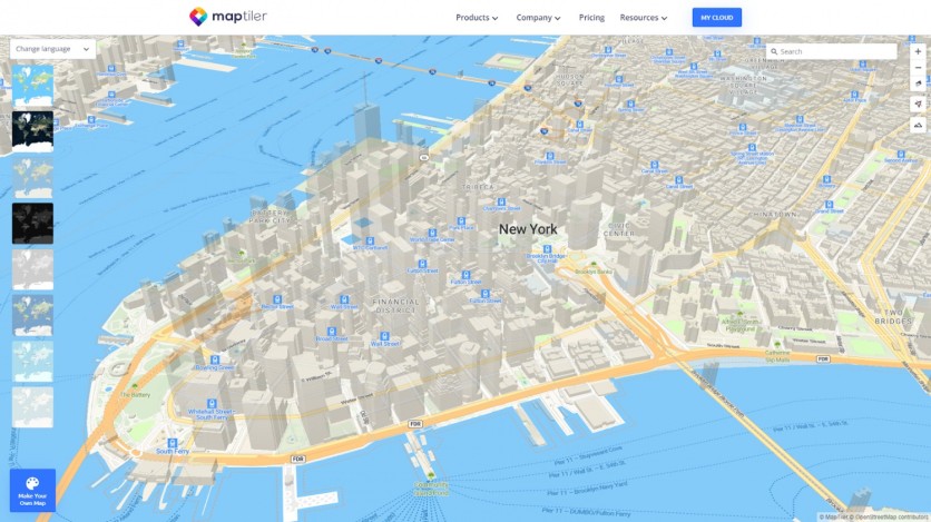
The mapping software has ready-to-use base maps to serve as the foundation of web maps. These include satellite, street, outdoor, dataviz, and 3D maps. They are also available for customization to deliver the objectives of the brand. Developers can also upload their tiles for map hosting from the reliable global infrastructure of MapTiler.
JavaScript Maps SDK
MapTiler's JavaScript Maps SDK offers an environment for creating interactive vector and raster maps through the open-source TypeScript library of the mapping software. Developers can make web maps more interactive by adding filters or clickable features to improve map visualization. They can animate the map camera around a single location to present the 3D design of a city or display a 3D terrain map of a country.
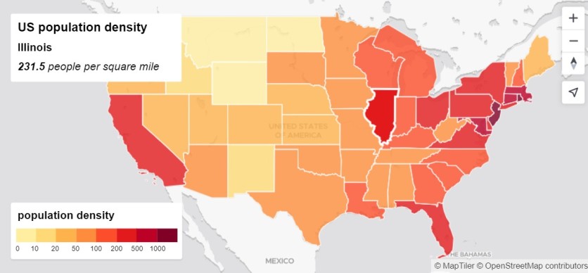
MapTiler has also greatly simplified the way developers add features such as map controls to their maps. Moreover, by using its JavaScript maps SDK, developers can connect their web maps with analytics to display information like population density or statistical information.
MapTiler can also offer real-time data filters for users to easily locate information that meets their search criteria. Similar to the visual elements, developers can simply adjust the properties of the web map to highlight information that's needed by their audience.
MapTiler is a dedicated map provider, hence, its sole focus lies on creating digital mapping solutions businesses and end-users can benefit from. They guarantee no external influences factor in the implementation of their services, ensuring the privacy of end users is safe and protected.
From its multiple customizations, built-in language localization, and open-source SDKs, companies can leverage MapTiler to develop web maps for the flexibility and personalization it can offer. This mapping software can improve map visualization and map literacy for everyone with the amount of information and visual elements it can provide.
2 Google Maps Platform

Overview
The Google Maps Platform is a web service by a multinational technology company that offers detailed geographical information about regions and sites worldwide. Developers can use its APIs and SDKs to embed the web mapping platform into applications or web pages. It can offer efficient routes, provide local information, support rides and deliveries, and more.
Features
Google Maps offers real-time traffic updates. It offers the best route when traveling with its ability to display traffic jams, accidents, and other road-related problems drivers want to avoid. It also provides real-time updates for public transportation, highlighting crucial information such as estimated time of arrival or time of departure.
With a redesigned Explore tab, anyone can locate restaurants, hotels, and other establishments, making city explorations quick and easy. Businesses can utilize the web mapping platform to make their services accessible. Google Maps can show the direction to the target destination and related information about the establishment like its menu and reviews. Users can make advanced bookings or inquire online directly through the platform.
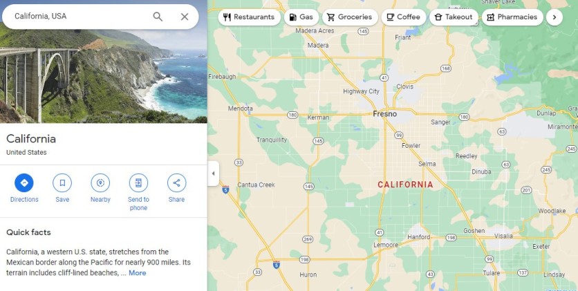
Google Maps also offers a Live View feature to help users effectively navigate and reach their location, regardless if it's indoors or outdoors. Users can also benefit from using aerial and satellite views, allowing them to prepare ahead of time when traveling to a new city. With its ease of use, navigation features, and customizations, it's an all-in-one mapping solution for businesses and consumers alike.
3 Mapbox

Overview
As a company, Mapbox drives innovation in the field of navigation for people, packages, and transportation. Over 700 million active users benefit from their maps, and over 3.9 million developers have built their maps through its SDKs and API. Companies like Meta, Microsoft, and Uber have utilized their mapping software to drive their businesses.
Features
The platform of Mapbox is backed by a globally distributed network, which ensures low latency delivery of its web maps and availability even during challenging scenarios like natural disasters. It can handle tens of thousands of requests per second, scalable to the organization's needs.
It offers Core Styles base maps developed by professional cartographic designs. They are customizable in the Mapbox Studio. It enables users to take control of every detail and property of the web map, including uploading and creating custom geodata. Mapbox also supports cross-platform SDKs, ensuring a seamless experience for users accessing the maps on web browsers or mobile.
Moreover, with MapBox Tiling Service, users can upload and transform their geospatial data into customizable maps and services within the platform. It can process massive data sets and sync them automatically across multiple regions where they are accessed. Overall, Mapbox is ideal for large companies looking for mapping software that can cater to a global audience.
4 TomTom

Overview
TomTom Maps Platform is a standardized map database built on an expanding network of mapping data, validated and standardized by OverTure Maps Foundation, OpenStreetMap, partner data, sensor-derived observations, and TomTom's proprietary data. With the richness of open data and proprietary data, many brands such as Uber, Ford, and Mitsubishi Motors leverage the mapping software to create accurate and reliable web maps.
Features
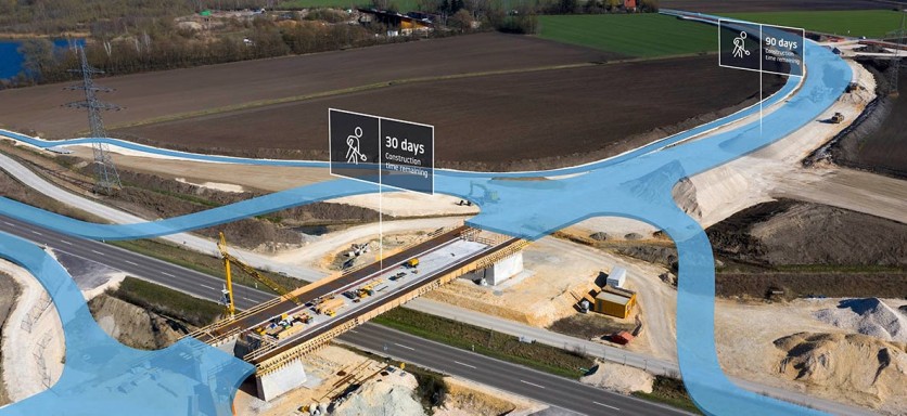
TomTom utilizes machine learning and AI to process large volumes of data and create accurate, updated web maps. It conducts quality checks to detect changes in locations. Together with input from social institutions and qualified authorities, it displays in real-time the ongoing constructions and other road projects that affect the road navigation of end-users.
It also features Address Point, which increases the geocoding accuracy of the maps by associating the specific street addresses to physical buildings, enabling faster address identification and last-mile navigation. Built with text-to-speech technology, TomTom offers instructions in local dialects and regional accents, making it safe and easy for drivers to navigate the road, especially when exploring a new city.
To enhance the user experience, TomTom offers points of interest where food, hotel, and retail establishments are highlighted, even gas stations or vehicle charging points. The mapping software supports over 30 languages and offers web map customization through its SD Map and maps API. Trusted by the world's biggest tech and automotive companies, businesses can leverage the web mapping platform for its expansive database and fast map delivery
5 HERE

Overview
HERE allows customizable maps and spatial intelligence content to be built through its platform. It can transform data, generate insights, and build applications through its map-making tools and technologies. Anyone can easily make web maps according to the needs of the user. As you create individually or collaboratively, HERE ensures user privacy and protection of business data and intellectual property.
Features
The mapping software platform of HERE enables customization. Users can modify the web map's markers, colors, and stylistic elements to highlight specific areas. They can also layer the maps with more information, such as roads, POIs, postal code points, and 3D landmarks. With every edit made, HERE automatically updates the changes in real-time to ensure consistency and accuracy of geographical information.

HERE has an easy-use-to-dashboard where users can manage their visualizations. They can layer, combine, edit, and even filter data, and these instantly reflect on the content of the web map. Moreover, it can include data or algorithms relevant to the business.
HERE also offers location services, SDKs, and tools to improve the customized private maps for seamless integration, allowing users to monetize their web maps through the HERE Marketplace.
This web mapping platform is also ISO/IEC 27001 certified and SSAE SOC Type 2, GDPR, and CCPA compliant, proving its credibility to uphold the industry standards. Overall, HERE can streamline operations and improve the user experience through real-time updates and visually appealing, customizable web maps.
In Summary
To summarize, below are the main reasons to use these five web mapping platforms:
MapTiler: customizable maps, built-in localization, open-source SDKs, no user tracking, advanced user traffic analytics, more map datasets, customer data hosting services, standardized weather data and visualizations, offline maps solution, easy account set up, no ads-based results, 2-4x cheaper, better quality cartography, highly-rated customer support
Google Maps: ease of use for the most basic of use cases, real-time data, rich geospatial data, simplified trip planning, assisted route navigation
Mapbox: global infrastructure, scalable, the best for companies with a global audience
TomTom: real-time traffic data, driver assistance systems, increased geocoding accuracy, full control of data, customizable maps, large database
HERE: modern interface, customizable web maps, real-time updates, industry certifications
Conclusion
Creating custom, visually appealing, and versatile web maps requires access to real-time information to ensure that accurate geographical information is communicated to the audience. After all, the stylization of maps serves no purpose if a web map fails to deliver relevant and reliable information to the end user.
Each of these web mapping platforms has a unique selling point. It is recommended to choose based on one's objective and the solutions they can offer to improve overall map visualization and map literacy of your target audience.
ⓒ 2026 TECHTIMES.com All rights reserved. Do not reproduce without permission.


