NASA's recent capture of Typhoon Mawar's fury in the Pacific has brought attention to the powerful storm that targeted the Mariana Islands in late May 2023 as reports indicate that the typhoon was one of the strongest to strike the US territory of Guam in decades.
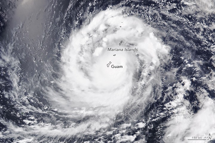
The image, taken by the Visible Infrared Imaging Radiometer Suite (VIIRS) on the NOAA-20 satellite, shows the extent of Typhoon Mawar's reach as it approached Guam on Wednesday, May 24.
At that time, the storm had sustained winds of approximately 140 miles (225 kilometers) per hour, making it equivalent to a category 4 storm on the Saffir-Simpson wind scale.
Powerful Winds and Heavy Rainfall
The image depicts the typhoon's cloud bands enveloping the islands, accompanied by powerful winds and heavy rainfall.
Interestingly, the area of brightness observed in the image's top-left corner is known as sunglint-an optical phenomenon that is unrelated to the storm's presence.
Throughout its journey, Typhoon Mawar retained its category 4 strength, passing through the Rota Channel-a strait separating Guam and Rota-at around 9 p.m. local time on May 24, according to NASA.
The eye's southern wall swept across a significant portion of Guam, subjecting the northern-third of the island to the most extreme winds, as reported by the US National Weather Service.
By May 25, the typhoon began moving west-northwest, gradually distancing itself from the islands. Although the full extent of the storm's impact on Guam remained uncertain, initial reports indicated widespread power outages, fallen trees, and coastal flooding.
In light of the severity of the circumstances, US officials acknowledged the significance of the situation and declared a state of emergency in the region on May 22.
This declaration granted authorization for specific measures and dedicated resources to facilitate disaster relief efforts.
Read Also : Storm-Tracking NASA Satellite Constellation's New Launch Date Announced! Here's When It'll Happen
Opportunity for Scientists
In the midst of this natural calamity, NASA's latest capture presents an opportunity for scientists to gain insights into tropical cyclones like Typhoon Mawar.
The final launch of NASA's Time-Resolved Observations of Precipitation structure and storm Intensity with a Constellation of Smallsats (TROPICS) mission was scheduled for no earlier than 12 a.m. Eastern Time on May 25.
Utilizing small satellites resembling shoeboxes, the TROPICS mission is focused on gathering crucial data pertaining to temperature, precipitation, water vapor, and clouds.
This valuable data has the potential to offer valuable insights into the formation and intensification of storms, providing scientists with valuable knowledge about tropical cyclones.
Related Article : [UPDATE] Dead NASA Satellite to Crash Into Earth! Should You Be Worried? Here are RHESSI's Re-Entry Details

ⓒ 2025 TECHTIMES.com All rights reserved. Do not reproduce without permission.


