National Aeronautics and Space Administration (NASA) revealed how serious the explosion that occurred in Beirut by mapping the extent of the damage. According to CNET's latest report, the space agency revealed the location where the worst damage happened by using a synthetic aperture radar.
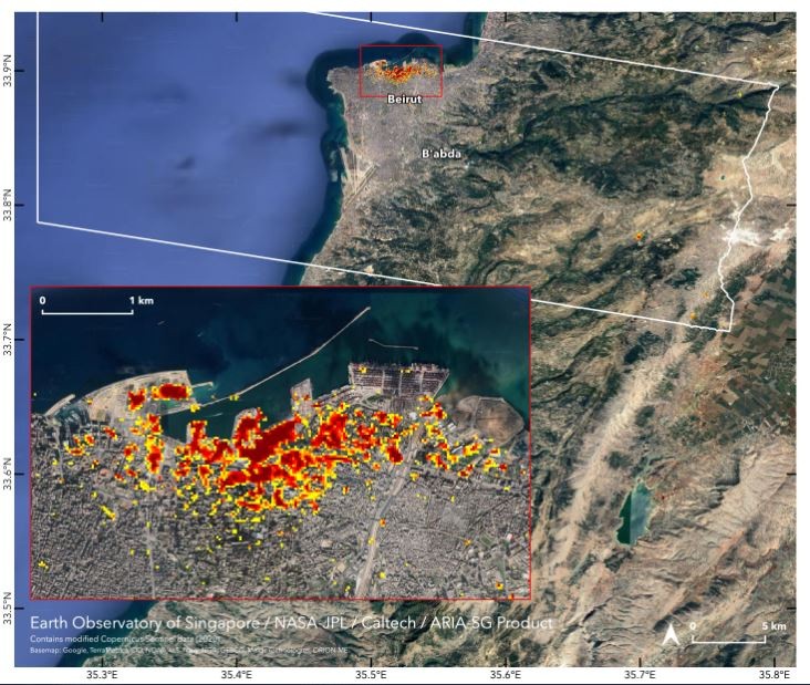
Damage from the massive explosion in Beirut can be seen from space. In the map, dark red pixels represent the most severe damage. Each pixel represents an area of 30 meters (33 yards). https://t.co/YpMEeuPjKJ pic.twitter.com/b6ZRQcjlOK — NASA JPL (@NASAJPL) August 7, 2020
Also Read : Satellite Images Show 20% More Population of Emperor Penguin; 11 New Colonies Found in Antarctica
A satellite image was released, showing the severe damage caused by the Beirut explosion, which happened on Aug. 4. The picture, which was published on Friday, Aug. 7, was captured by NASA's Advanced Rapid Imaging and Analysis (ARIA) together with the Earth Observatory of Singapore in NASA's Jet Propulsion Laboratory located at Catech.
Read also: Canada's Arctic Meltdown: Collapsing Lost 40% Ice Mass in Two Days, Result of Arctic Amplification
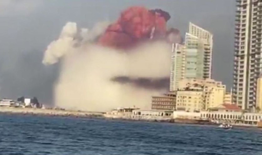
Around 150 people succumbed to the explosion caused by a stockpile of ammonium nitrate, which was stored at the port for years. The tragedy that happened in Beirut, Lebanon, which was heard as far as Cyrus, left thousands of people wounded.
The report explained that NASA map uses pixels in different shades of red and yellow, to reveal the damage difference caused by the explosion. The darkest red part represented the most severe damage around the Port of Beirut. Moderate damage is represented by the part shaded by orange pixels, while the less severe damage is in yellow pixels. Each of the pixels covers an area around 33 yards.
The report claimed that the map released by NASA could help the local authorities to locate the areas where help is needed the most.
Before-and-after images of Beirut explosion were released
According to the previous report of CNET, Maxar and Planet Labs launched before-and-after photos of the explosion to show the damage it caused. Videos were shared by the survivors online to show the destruction extent from ground level.
Ignorance of news services on #Beirut attack infuriating!
As a chem teacher: mere presence of ammonium nitrate is not the *reason* for tailored 'pseudo-thermobaric' explosion!
NH4NO3 is not explosive unless a *better explosive* or *exceptionally intense* fire triggers it! #auspol pic.twitter.com/4VCfymAmYK — Speaking4myself (@neoversussmith) August 7, 2020
On Wednesday, Aug. 5, Planet Labs and Maxar Technologies revealed Beirut's images before and after the explosion happened on Twitter. SkySat's images from May 31 and Aug. 5, revealed how severe the damage is.
Before and after SkySat imagery shows the impact of yesterday’s explosion in Beirut.
Imagery captured on May 31, 2020 and today, August 5, 2020. pic.twitter.com/8zCLDOZn4w — Planet (@planetlabs) August 5, 2020
Planet Labs share the photos, showing that large port sections were damaged or even entirely missing. In the center-right of the picture, a cruise ship can be seen lying on its side, which shows the strong force of the explosion.
A series of even more detailed satellite images were also posted on Twitter by Maxar, showing the port and surrounding areas.
"Take a look at the large crater, the capsized Orient Queen and buildings with blown-out, shattered glass," captioned the company.
Getting behind the major events taking place across the globe? Always keep your tabs open here at TechTimes.
Read also: Also Read: [VIRAL] Beirut Explosion: Never-Before-Seen Explosion Video Went Viral on Social Media
This article is owned by TechTimes.
Written by: Giuliano de Leon.
ⓒ 2026 TECHTIMES.com All rights reserved. Do not reproduce without permission.


