A new Google Map-alike software is now trending in social media, and everyone's using it to find their addresses. Compared to the standard Google Map, this new 'Ancient Map' shows your country's placement from way years ago-- specifically up to 750 million years ago. Here's how you can use it.
Have you tried the Ancient Earth Globe?
In 2018, a lot of people wanted to know how their countries were like a million years ago. And the software was there to guide them called the Ancient Earth Globe website.
If you wanted to know how your country was like before the dinosaurs or the Pangaea (a supercontinent that existed during the late Paleozoic and early Mesozoic eras), this software helps to identify the position and structure of your area before all the histories happened.
The Sun reported that the Ancient Earth Globe might be one of the coolest apps you will see today. Since its all pandemic, it is pretty great to see countries, way million years ago.
Paleontologist Ian Webster releases this software via Hacker News and it is now gaining more popularity than ever.
According to his narrative, he was amazed to see software that could track his place before Pangaea even started to be divided into continents.
"I'm amazed that geologists collected enough data to actually plot my home 750 million years ago, so I thought you all would enjoy it too. Even though plate tectonic models return precise results, you should consider the plots approximate (obviously we will never be able to prove correctness)," said by him. "In my tests, I found that model results can vary significantly. I chose this particular model because it is widely cited and covers the greatest length of time."
How to use the map to track your place?
If you want to know how your place was million years ago, here's how you can use the Ancient Earth Globe software.
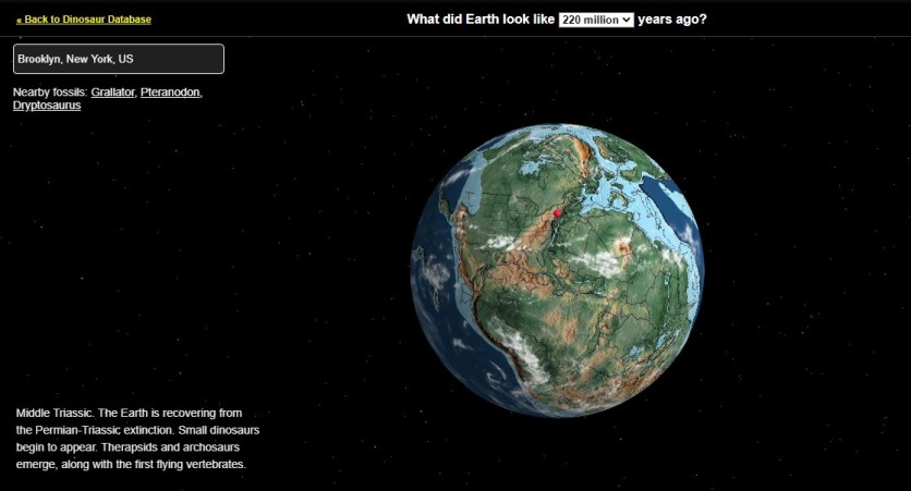
Just go to the link of the website named dinosaurpictures.org, and you will see a standard-looking world map. A question will pop at the website's upper side, asking you, "What did Earth look like (number of years) million years ago?"
At the 'enter the city' tab, type your country's name-- or even your city if you can. Then choose the number of years you want the map to rewind, and that will do the trick.
Walk from New York to Kenya

How cool is this map? Technically, this ancient map can make you walk from New York and head to Kenya, Africa. Of course, this will happen once you set the timeframe 240 million years ago, wherein the Pangaea was not yet breaking apart.
The super continent started to divide into seven continents until about 175 million years ago. So that map seemed to be right on that part.
ALSO READ: "Ice Ship" Found Near Antarctica Via Google Map Claimed to Be a Capsized Boat
This article is owned by Tech Times
Written by Jamie Pancho
ⓒ 2026 TECHTIMES.com All rights reserved. Do not reproduce without permission.


