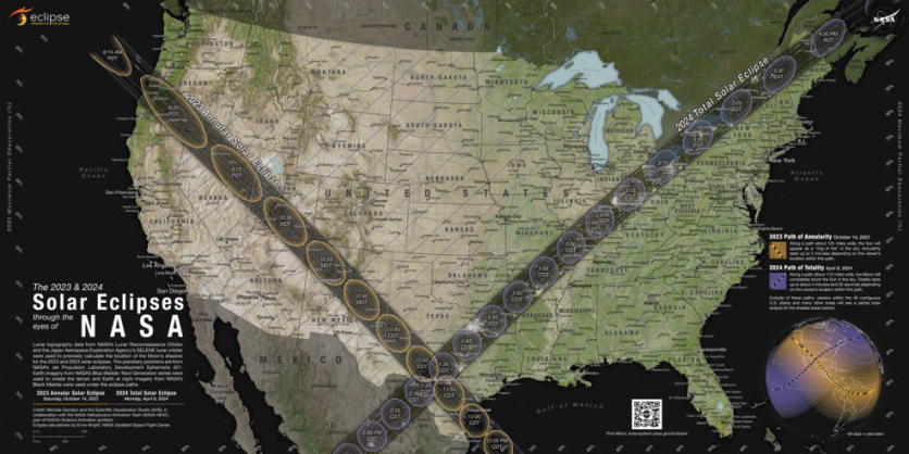
Solar eclipses are rare scenic sights that only a few of us can witness in our lives. However, we may soon plan ahead of time to watch these eclipses with NASA's new map detailing 2023 and 2024 solar eclipses in the US.
The map highlights the trajectory of the Moon's shadow as it traverses the contiguous United States during the annular and total solar eclipses.
"Ring of Fire"
Drawing on data gathered from several of NASA's missions, the map outlines the dark paths that span the country, indicating where onlookers can observe the "ring of fire" during the annular eclipse and the ghostly-white outer atmosphere of the Sun during the total eclipse.
The map also displays the locations where the Moon will partially block the Sun and the extent to which the Sun will be eclipsed in those regions.
On both October 14, 2023, and April 8, 2024, all 48 contiguous states in the US will experience a partial solar eclipse, in addition to parts of Canada and Mexico.
The paths for the annular and total eclipses appear as dark bands across the U.S. on the new eclipse map released by NASA.
For anyone positioned within the annular eclipse path, which stretches from Oregon to Texas, clear skies will offer a chance to observe the annular eclipse.
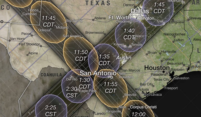
Likewise, those located in the total eclipse path, which runs from Texas to Maine, will have the opportunity to witness the total eclipse, provided that weather conditions permit.
The map displays two paths that indicate the trajectory of the total and annular eclipses. Each path has ovals that represent the shape of the Moon's shadow and the times when the total or annular eclipse will occur.
The color of the ovals differs, with yellow for the annular eclipse and purple for the total eclipse. The white lines inside each path indicate the duration of annularity or totality, with labels for annularity ranging from 3 to 4.5 minutes.

The labels for the total eclipse appear along the bottom and right edges of the map.
Viewers located within the path will experience either a total or annular eclipse, while those outside the path may still see a partial eclipse, which is represented by lines running parallel to each path. For the annular eclipse, the lines are faint yellow, and for the total eclipse, they are faint purple.
Solar Eclipses Outside the US
The two upcoming eclipses, annular and total, will not be limited to the contiguous US. According to NASA's map, the annular eclipse's path (in yellow and black) will extend across Mexico, Central America, and South America, while the total eclipse (in purple and black) will cross northeastern Canada and Mexico.
To create the map, NASA used various sources of information, such as Earth elevation information from the Shuttle Radar Topography Mission, maps of the Moon's shape from the Lunar Reconnaissance Orbiter, and data from NASA's Navigation and Ancillary Information Facility.
Related Article : NASA's Roman Space Telescope Simulates Millions of Stunning Galaxies in Deep Field Image

ⓒ 2026 TECHTIMES.com All rights reserved. Do not reproduce without permission.


