NASA's Earth Observatory captured satellite images of the devastating Turkey-Syria earthquake that occurred on Feb. 6 to show the extent of its damages.
Large and Powerful Earthquakes
According to NASA, the initial earthquake was caused by a fault that was located 18 kilometers (11 miles) beneath the surface of the earth. Due to the shallow depth of the earthquake, it produced intense shaking that affected areas hundreds of kilometers away from the epicenter.
It was then followed by a 7.5 magnitude earthquake after nine hours and hundreds of small aftershocks.
Following the event, space agencies such as NASA processed and analyzed satellite data to understand the extent of the damages.
"These were very large and powerful earthquakes that ruptured all the way up to the surface over a long series of fault segments," Eric Fielding, a geophysicist at NASA's Jet Propulsion Laboratory, said in a statement.
"This generated extremely strong shaking over a very large area that hit many cities and towns full of people. The rupture length and magnitude of the magnitude 7.8 earthquake was similar to the 1906 earthquake that destroyed San Francisco."
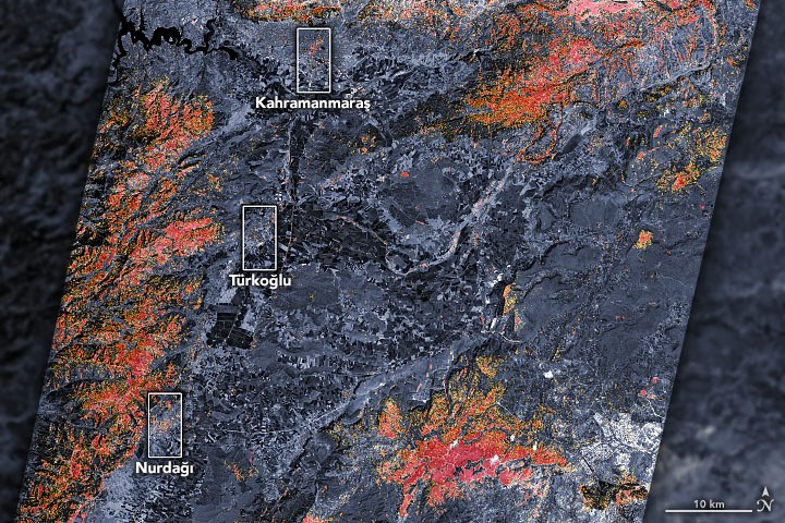
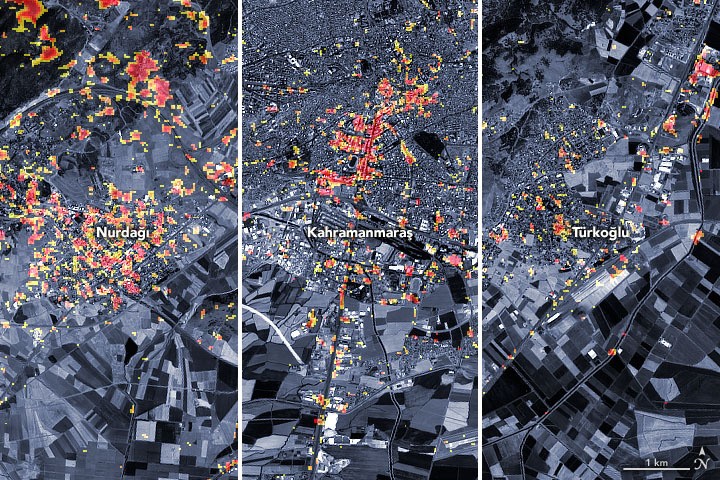
Parts of the cities of Türkoğlu, Kahramanmaraş, and Nurdaği are visible on the preliminary damage proxy map provided by NASA. Orange and yellow areas are significantly or partially damaged, while dark red pixels signify locations anticipated to have serious damage to buildings, residences, infrastructure, or changes to the landscape.
PALSAR-2
The map was created using information gathered on February 8, 2023, by the PALSAR-2 on board the Advanced Land Observing Satellite-2 (ALOS-2).
The satellite has a synthetic aperture radar, a sensor that emits microwave pulses toward the planet's surface in order to map landscapes.
Scientists started identifying damaged locations by comparing the data from February 8 to measurements collected by the same satellite before the earthquake on April 7, 2021, and April 6, 2022.
The Earth Observatory of Singapore's Remote Sensing Lab worked with NASA Jet Propulsion Laboratory, Caltech, and Sentinel Asia to evaluate the ALOS-2 data.
Organizations like the US State Department, the California Seismic Safety Commission, Miyamoto Global Disaster Relief, and the World Bank are now in the process of receiving the damage proxy map, according to NASA.
The team also evaluates the needs of regional stakeholders as part of regular coordination calls run by the US Agency for International Development, and it provides its scientific expertise to initiatives for risk assessment and recovery.
Shanna McClain, the manager of the program, said that they are closely monitoring the event to help recovery efforts.
They are utilizing satellites to monitor increased landslide risks, power outages, and weather that could complicate response efforts in addition to providing satellite mapping of damages.
The team is updating its mapping platform with earthquake-related images and data products in real-time as new information becomes available, according to NASA.
Related Article : NASA Will Land On The Moon For The First Time in 50 Years l Here's Everything You Need To Know About Artemis 1

ⓒ 2025 TECHTIMES.com All rights reserved. Do not reproduce without permission.


