A new baby island has surfaced in the southwest Pacific Ocean after an underwater volcano in Tonga's Central Islands erupted, according to NASA's Earth Observatory.
The island is rapidly growing while blasting molten lava, ash, and steam at least 1.8 miles (3 kilometers) into the sky.
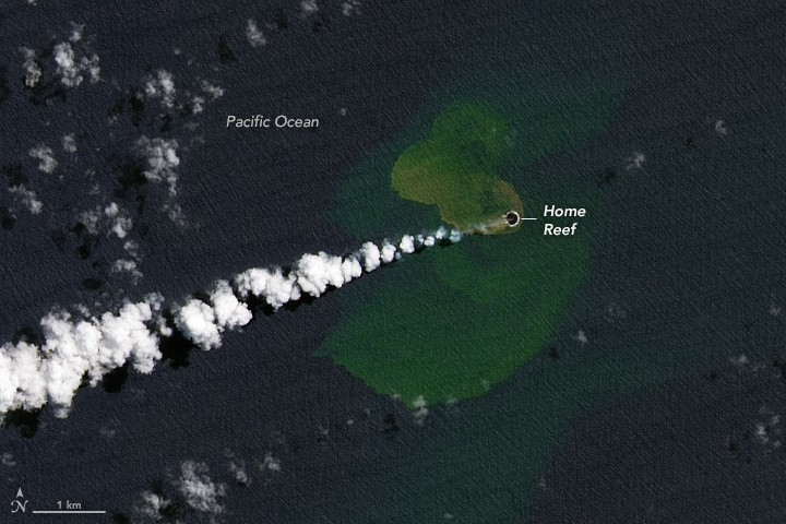
Creating the Island
In the southwest Pacific Ocean, along a seafloor ridge that stretches from New Zealand to Tonga, lies the highest concentration of underwater volcanoes in the entire world. One of them erupted on September 10, 2022.
After the eruption, the Home Reef seamount continuously emitted ash and steam plumes, leaked lava, and tainted the surrounding water. But more importantly, a new island appeared above the water's surface eleven hours after the eruption.
Images captured on September 14 by the Landsat 9 satellite showed how the island was formed. In the picture, a large cloud of steam and ash is rising from the volcano.
Previous research indicates that sulfur, volcanic rock pieces, and particle debris are present in these superheated, acidic seawater plumes, according to NASA.
The term "seamount" refers to volcanoes that are submerged in water. Lava from underwater volcanoes that erupt forms an undersea ridge. Lava accumulates in layers until a ridge breaks the sea's surface to create an island.
New Island
The new island was first thought to be 4,000 square meters (1 acre) in size and 13 feet (10 meters) above sea level, according to scientists from Tonga Geological Services. But on September 20, it had expanded to 24,000 square meters (6 acres).
The young island is situated southwest of Late Island, northeast of Hunga Tonga-Hunga Ha'apai, and northwest of Mo'unga'one. According to NASA, the fastest global convergence of three tectonic plates is seen at the Tonga-Kermadec subduction zone.
One of the planet's deepest holes and most active volcanic arcs are created here as the Pacific Plate collides with two smaller plates and sinks.
NASA noted that Islands formed by submerged volcanoes are usually transient, but they may last for years. There have been four reported eruption periods at Home Reef, including occurrences in 1852 and 1857.
Small islands were momentarily constructed following both events, while eruptions in 1984 and 2006 also produced short-lived islands with cliffs that were 50 to 70 meters high.
The island formed by the adjacent Late'iki Volcano's 12-day eruption in 2020 washed away within two months, although the island formed by the same volcano in 1995 lasted for 25 years.
The Tonga Geological Service stated in an update released on September 20 that "the volcano poses low risks to the aviation community and the residents of Vava'u and Ha'apai."
"All mariners are, however, advised to sail beyond 4 kilometers away from Home Reef until further notice."
Related Article : [WATCH] An Expedition Team Captures the Highest Quality Footage of Titanic - Detailing Shipwreck in Stunning 8K!
This article is owned by Tech Times
Written by Joaquin Victor Tacla
ⓒ 2026 TECHTIMES.com All rights reserved. Do not reproduce without permission.


