NASA has released a new high-resolution global image of Mars that provides an immersive look at the Red Planet. The image is a mosaic of 110,000 black-and-white images taken by NASA's Mars Reconnaissance Orbiter (MRO) over the past 17 years.
These images were captured by MRO's Context Camera (CTX), which provides a broader view of the terrain around surface features, helping scientists understand how they are related.
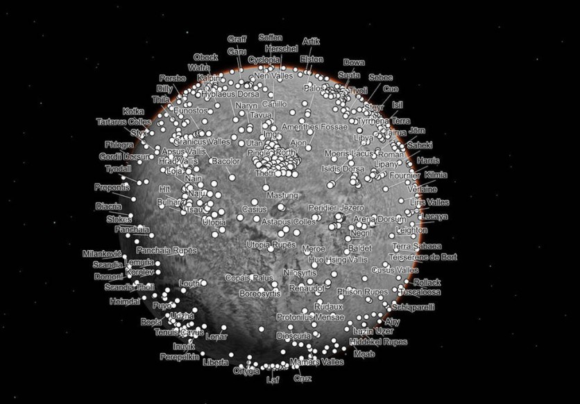
Highest-resolution Global Image of Mars
The new image, created by Caltech's Bruce Murray Laboratory for Planetary Visualization, is the highest-resolution global image of Mars ever created. It covers nearly 270 square feet (25 square meters) of surface per pixel, making it so detailed that it has already been cited in more than 120 peer-reviewed scientific papers.
The mosaic took six years and tens of thousands of hours to develop, and its resolution is so high that if it were printed out, it would be large enough to cover the Rose Bowl Stadium in Pasadena, California.
The image is also easy enough for anyone to use, with the goal of lowering the barriers for people who are interested in exploring Mars.
The new image is a component of the Planetary Data Archiving, Restoration, and Tools (PDART) initiative of NASA, which aids in the creation of fresh applications for current NASA data.
The program's goal was to increase accessibility to the scientific byproducts of extended missions like MRO.
CTX Camera's Extensive Coverage
As a result of the CTX camera's extensive coverage of Mars since MRO's arrival in 2006, according to Jay Dickson, the image processing scientist who oversaw the project and oversees the Murray Lab, its photographs make for an excellent starting point for researchers when they are building a map.
Dickson used an algorithm to match photographs based on the features they recorded to produce the new mosaic. The remaining 13,000 photos that the algorithm could not match were pieced together manually by the scientist.
The remaining gaps in the mosaic indicate regions of Mars that were either not yet surveyed by CTX when Dickson started working on this project or regions that were covered by clouds or dust.
In addition to visiting Olympus Mons, the largest volcano in the solar system, and adding topographic data from NASA's Mars Global Surveyor mission, the new image enables users to hop to places being investigated by the Curiosity and Perseverance rovers, including Gale Crater and Jezero Crater.
One of the mosaic's outstanding features is its highlighting of impact craters over the whole planet, which helps viewers understand how scarred Mars is.
"For 17 years, MRO has been revealing Mars to us as no one had seen it before," said Rich Zurek of NASA's Jet Propulsion Laboratory. "This mosaic is a wonderful new way to explore some of the imagery that we've collected."
Related Article : NASA Perseverance Rover's Lightsaber Image Excites 'Star Wars' Fans; Here's What the Metal Tube Really Is

ⓒ 2026 TECHTIMES.com All rights reserved. Do not reproduce without permission.


