One of the most powerful storms the area had seen in recent years hit Western Australia on Thursday, April 13. NASA captured a satellite view of the storm ravaging the region.
Tropical Cyclone Ilsa made landfall in the region, carrying winds that gusted to around 300 kilometers (190 miles) per hour.
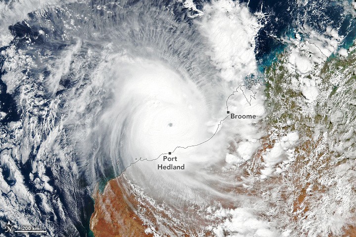
Ilsa's Scale and Intensity
The storm, which had been building for days, was closely monitored by the Visible Infrared Imaging Radiometer Suite (VIIRS) sensor on the NASA-NOAA Suomi NPP satellite.
Earlier that day, the VIIRS sensor acquired an image of the storm, providing a unique perspective of its scale and intensity.
"Around the time of this image, Ilsa was approaching the coast with 240 kilometers (150 miles) per hour winds. That equates to a category 5 storm on Australia's intensity scale, which is equivalent to a category 4 storm on the Saffir-Simpson hurricane wind scale," NASA wrote in the image release.
"Although the storm's center had not yet reached the coast, its outer cloud bands were already interacting with land."
The image showed that the storm had a relatively small eye, sometimes called a "pinhole" eye. Such storms tend to spin faster and wield more potent winds.
Bedout Island, where ground-based instrumentation recorded persistent wind speeds of 218 kilometers per hour (135 miles per hour), was particularly hard hit by the storm.
The previous record for the island was 194 km/h, recorded during Cyclone George in 2007. The island, however, was not visible in the satellite photograph.
Forecasters anticipated the storm would slow down as it headed inland through the Pilbara region and Western Australia's Northern Interior.
However, communities could still be at risk from catastrophic winds and torrential rain when the storm passes across the region, despite the relatively low population of the area, according to NASA.
Valuable Tool
The image captured by the VIIRS sensor provides a valuable tool for meteorologists and emergency responders who need to understand the extent and impact of the storm.
It allows them to see the storm's movement and intensity in real-time and make more informed decisions about evacuations and emergency response efforts.
The satellite data is also critical for researchers who study the patterns and behavior of storms like Cyclone Ilsa.
By analyzing the data, scientists can gain insights into the factors contributing to the development and intensity of tropical storms and hurricanes.
This image is just one example of how NASA and NOAA's satellite technology can help us understand and prepare for extreme weather events.
The agencies' advanced sensors and data analysis tools provide critical information to help save lives and protect property during natural disasters.
Related Article : NASA Will Land On The Moon For The First Time in 50 Years l Here's Everything You Need To Know About Artemis 1

ⓒ 2026 TECHTIMES.com All rights reserved. Do not reproduce without permission.


