NASA's Ice, Cloud, and Land Elevation Satellite 2, also known as ICESat-2, captured the attention of the world after Daichi Fujii, a museum curator in Japan, captured footage of the satellite's green laser beams streaming from orbit to Earth.
The beams were visible in a video taken on September 16, 2022, and were synchronized with a tiny green dot that appeared between the clouds.
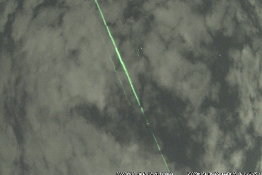
Was it a meteor?
Fujii initially thought the green light could be a meteor. However, he realized it was a satellite after investigating the orbital data and getting a match.
He then posted his findings on social media, which eventually reached the ICESat-2 team.
According to Tony Martino, ICESat-2 instrument scientist at NASA's Goddard Space Flight Center in Greenbelt, Maryland, it was the first time the team had seen footage of the satellite's green laser beams streaming to Earth.
Martino said the ICESat-2 appeared to be directly overhead, with the beam hitting the low clouds at an angle, which made it visible.
The laser light is not harmful and is fired from hundreds of miles up in space. If someone were to stand directly under the satellite and look up, the laser would only have the strength of a camera flash more than 100 yards away.
The beam is difficult to spot since cameras and eyes require laser light to reflect off something to view the beam from the side. The atmospheric conditions also play a vital role in making the beam visible, according to Martino.
Read Also : NASA's James Webb Space Telescope Unveils Previously Unknown Details of Supernova Remnants
ICESat-2's Laser Technology
Launched in September 2018, ICESat-2 employs laser technology called lidar to measure the elevation of Earth's ice, water, and land surfaces from space.
By emitting six beams of light at a rate of 10,000 times per second, the lidar measures the amount of time it takes for photons to bounce back from the Earth's surface to the satellite with precise timing.
These measurements are then used by computer programs to calculate various phenomena such as the loss of ice in Greenland and Antarctica, the amount of frozen polar oceans, the elevation of freshwater reservoirs, and the mapping of shallow coastal regions, according to NASA.
The ICESat-2 team is not the only group to attempt to capture the satellite's photo. People in southern Chile and Oklahoma have been able to snap photos of the satellite when it passed over.
According to Martino, detecting the laser light is challenging, as it requires being in the precise position at the correct moment with favorable atmospheric conditions.
In this instance, the laser light was scattered by just enough clouds, allowing cameras to capture it without being entirely blocked by them.
After analyzing the ICESat-2 data, which displays the ground and clouds, Martino verified that the laser beams were indeed emitted from ICESat-2.
Related Article : Asteroid Didymos' Spinning Activity Confuses NASA; New Study Shows Rock Completes Rotations in Just 2 Hours!

ⓒ 2026 TECHTIMES.com All rights reserved. Do not reproduce without permission.


