Artificial intelligence (AI) is reshaping our understanding of poverty by providing a unique and haunting visual. Researchers from Lund University and Halmstad University have employed a deep convolutional neural network (DCNN), a sophisticated AI algorithm used for visual imagery analysis, to study satellite imagery and identify poverty levels with a remarkable accuracy comparable to household surveys.
AI in Poverty Assessment
The researchers noted in an article published in The Conversation that combatting poverty entails knowing where aid is most needed, which is crucial. Traditionally, this has been accomplished through household surveys, which are often infrequent and cover limited locations.
The emergence of AI, particularly the use of DCNN, represents a transformative shift in how poverty and human development indicators can be measured.
Using satellite imagery, the AI model developed by the research team demonstrated the potential to monitor and identify areas needing aid, particularly in rapidly changing land-use scenarios. According to the research team, this method offers a faster and more comprehensive alternative to ground surveys, enhancing the efficiency of aid delivery.
The researchers used a DCNN, a type of deep learning technology, initially trained on a vast dataset of labeled images from the ImageNet repository. Subsequently, the model was fine-tuned using daylight satellite images of populated areas.
This specialized training enabled the AI to outperform human observers in assessing poverty levels from low-resolution daytime satellite images, showcasing its superhuman capabilities similar to AI successes in fields like chess and Go.
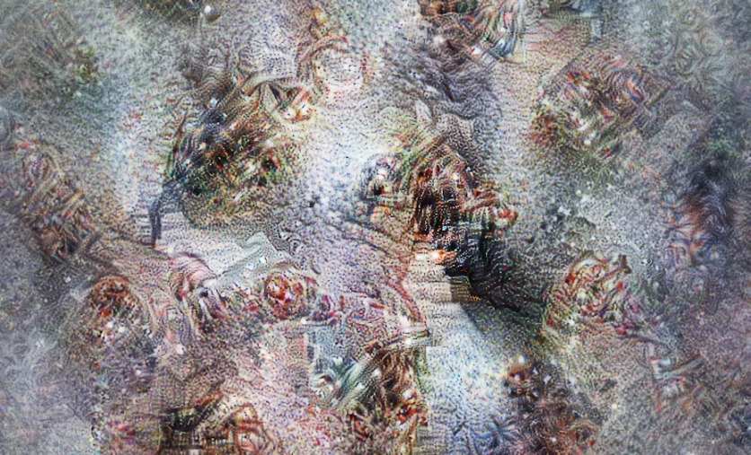
The researchers embarked on a unique exploration to gain insights into the AI's decision-making process. Starting with a "blank slate" image of a Tanzanian village categorized as "poor" by the AI, the researchers systematically adjusted the image by introducing features associated with higher wealth, such as roads and buildings.
This step-by-step transformation revealed the specific features and patterns that the AI associated with wealth in satellite imagery.
AI's Thought Process
While abstract and surreal, the resulting visualizations offer a glimpse into the AI's "thought process" and its interpretation of wealth. The ethereal images hint at clusters of interconnected homes, roads, and even coastal areas, reflecting the network's understanding derived from its training data.
However, the researchers acknowledged the inherent randomness in these visualizations, emphasizing that they represent the network's perception rather than an objective depiction of wealth. The limitations of machine learning in mirroring human understanding are apparent, highlighting the complexities involved in poverty assessment.
"This is where the real value of AI in poverty assessment lies, in offering a spatially nuanced perspective that complements existing poverty research and aids in formulating more targeted and effective interventions," the researchers wrote.
The study's findings can be found here.

ⓒ 2026 TECHTIMES.com All rights reserved. Do not reproduce without permission.


