NASA forecasts indicate that glaciers worldwide are anticipated to shed more than 40 percent of their mass, contributing approximately 3.5 inches to the rise in sea levels by the year 2100. However, scientists examined radar datasets to assess the risk of subsidence along the Eastern Seaboard of the United States.
Experiencing Gradual Sinking
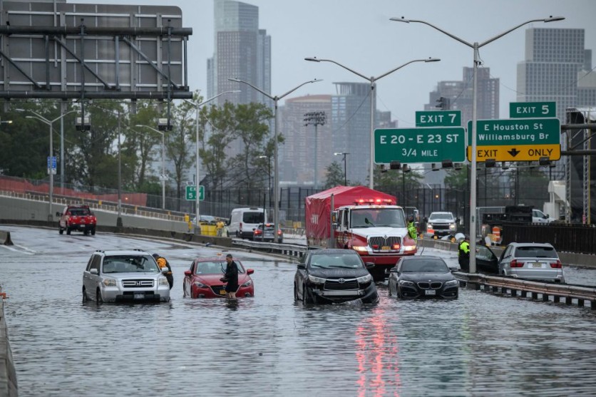
A recent study asserts that the US Atlantic Coast is experiencing a gradual sinking, measuring up to 5 millimeters per year. The research indicates that over 50 percent of infrastructure in prominent cities such as New York, Baltimore, and Norfolk is subjected to similar subsidence rates ranging between 1 and 2 millimeters annually.
Utilizing radar datasets, Interesting Engineering reported that the study delved into the assessment of subsidence-hazard exposure along the U.S. East Coast.
The primary objective of the research was to evaluate the implications of land subsidence on coastal communities, with a specific focus on the hazards it poses to the population, assets, and infrastructure systems in major cities.
Scientists emphasize that coastal communities encounter numerous risks, particularly the heightened vulnerability to multiple hazards exacerbated by land subsidence, predominantly due to the concentration of numerous assets in these regions.
Mitigating Strategies
The prospect of climate change introducing multiple hazards has prompted experts to advocate for proactive mitigation strategies.
The investigation unveiled significant findings, indicating that an expansive land area spanning from 2,000 to 74,000 square kilometers, with a population ranging between 1.2 to 14 million people, and numerous properties face exposure to subsidence rates falling between 1 and 2 millimeters annually.
Additionally, more than half of the infrastructure in major cities such as New York, Baltimore, and Norfolk is confronted with the same subsidence rates.
As reported by Newsweek, specific regions along the U.S. Atlantic coast are experiencing a sinking rate of five millimeters (0.2 inches) each year.
The study emphasized that the subsidence rates of 2 mm per year affect a maximum of 2.1 million people, 867,000 properties (median exposure), and significant infrastructure on the East Coast of the United States.
Lead researcher Leonard Ohenhen, a graduate student from Virginia Tech's Earth Observation and Innovation Lab, expressed concern about the ongoing and unchecked subsidence along the U.S. East Coast.
As published in the journal PNAS Nexus, he noted that the continuous subsidence should raise alarms, particularly in regions with high population and property density, coupled with a historical tendency to overlook infrastructure maintenance.
To conduct the research, the team utilized measurements of vertical land motion rates obtained from radar datasets. They observed that areas experiencing higher subsidence rates were associated with a reduced extent of exposure to these hazards.
The authors underscored the broader implications of their analysis for community and infrastructure resilience planning. They stressed the importance of adopting a targeted approach to transition from reactive to proactive hazard mitigation strategies in the context of climate change.
Related Article : New York City's Fastest Sinking Locations Revealed in NASA-Led Study

ⓒ 2026 TECHTIMES.com All rights reserved. Do not reproduce without permission.


