Ever since Hurricane Ida made landfall on Sunday, August 29, the Category 4 hurricane has caused widespread damage to everything in its path. In fact, the damage is visible from space.
Satellite images taken by Maxar Technologies' Worldview-2 satellite have captured the aftermath of Hurricane Ida in certain parts of the country.
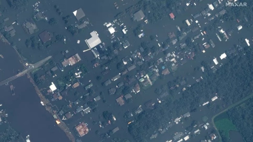
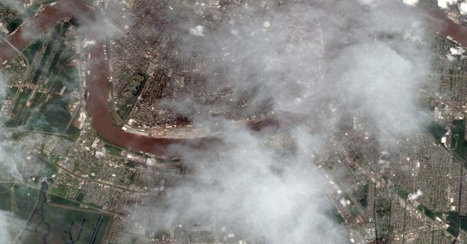
Hurricane Ida's storm surge and rain have caused massive flooding in areas where it hit, specifically in the Louisiana coast.
Hurricane Ida Damage as Seen in Satellite Images
The damage that Hurricane Ida has caused has been captured by the Worldview-2 satellite in images released to the public.
According to Space, the images captured by the Worldview-2 satellite are of cities and towns in Louisiana that have been hit by Hurricane Ida. These Louisiana towns and cities include La Place, Houma, and Jean Lafitte.
Per the Space report, the photos taken by the Worldview-2 satellite "show apartment complexes and other buildings with roofs torn to kindling by Ida's fury. Floodwaters submerge the streets and yards of Jean Lafitte."
One million people, according to Space, have no electricity as of Tuesday. These include residents of New Orleans.
Hurricane Ida
Hurricane Ida made landfall on Sunday as a Category 4 hurricane. According to the National Hurricane Center (NHC), a Category 4 hurricane has sustained winds of 130-156 mph. Hurricane Ida had sustained winds of 150 mph when it made landfall.
"Catastrophic damage will occur," according to the NHC website when a hurricane falls in that category.
Per the Space report, Ida has since weakened to a tropical depression. In its most recent tweet as of press time, the NHC said that the tropical depression is "moving across the Tennessee Valley."
Hurricane Ida is part of what is collectively known as the 2021 Atlantic hurricane season. Hurricane Ida hit Louisiana exactly 16 years after Hurricane Katrina, a Category 5 hurricane that caused more than 1,800 deaths.
Related Article: New Orleans Finally Has A Full-Scale Hospital One Decade After Katrina
The Worldview-2 Satellite
The Worldview-2 satellite, which captured photos of the aftermath of Hurricane Ida, was launched to space in 2009. It is owned by DigitalGlobe, a subsidiary of Maxar Technologies.
The European Space Agency (ESA) describes the Worldview-2 satellite as an "imaging and environment-monitoring satellite." According to the ESA website, the Worldview-2 satellite is sun-synchronous as far as its orbit type is concerned. It also has an orbit period of 100 minutes.
According to the Space report, the Worldview-2 satellite "zooms around Earth at an altitude of 480 miles (770 kilometers) and is capable of resolving features as small as 18 inches (46 centimeters) on the planet's surface."
A few days ago, the Worldview-2 satellite captured a photo of SpaceX's Falcon 9 rocket prior to its launch.
The objective of the Worldview-2 satellite, according to the ESA, is to provide high-resolution satellite imagery to meet growing demand.
Also Read: Dixie Fire Before-and-After Scenes Caught by Worldview-1 Satellite
This article is owned by Tech Times
Written by Isabella James
ⓒ 2026 TECHTIMES.com All rights reserved. Do not reproduce without permission.


