NASA has embarked on a mission to uncover ice deposits on Mars, recognizing them as a crucial resource for future human exploration. These ice reserves hold the potential to provide drinking water and serve as a fundamental component for rocket fuel production.
Moreover, they present a significant scientific opportunity to study Mars' climate history and investigate potential habitats for microbial life.
NASA's SWIM Project
Given the inhospitable Martian surface conditions, liquid water cannot exist in stable form. According to NASA, the thin atmosphere causes water to vaporize instantly. Although there is substantial ice content at the Martian poles, these regions are too frigid for extended human or robotic missions.
This necessitates the search for subsurface ice, a task undertaken by the NASA-funded Subsurface Water Ice Mapping (SWIM) project. SWIM, led by the Planetary Science Institute in Tucson, Arizona, and managed by NASA's Jet Propulsion Laboratory, has recently released its fourth set of detailed maps.
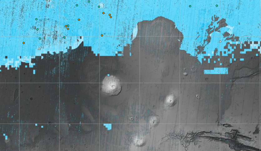
These maps, compiled from data collected by various NASA missions, including the Mars Reconnaissance Orbiter (MRO) and Mars Odyssey, pinpoint the most promising locations for accessing Martian ice from the surface.
The instruments aboard these spacecraft have identified potential frozen water deposits beneath the Martian surface, especially in the mid-latitudes. The northern mid-latitudes are particularly interesting due to their denser atmosphere, making them more suitable for spacecraft landings.
The optimal landing sites for astronauts would be situated at the southernmost edge of this region, striking a balance between proximity to ice and ensuring relatively milder temperatures. The new maps show where ice is most likely to be easily accessible to future astronauts.
The most recent SWIM map harnessed the enhanced capabilities of cameras aboard the Mars Reconnaissance Orbiter (MRO), integrating data from both the Context Camera and HiRISE. This yielded a finely detailed perspective on the boundary of the ice, extending even closer to the equator.
HiRISE observations unveiled impact craters that exposed substantial ice reservoirs, providing crucial confirmation of sub-surface ice presence. Moreover, the updated map encompasses HiRISE observations of "polygon terrain."
This phenomenon arises from the seasonal expansion and contraction of subsurface ice, resulting in the formation of distinctive polygonal cracks. These additional observations serve as further evidence for the existence of concealed ice deposits.
SWIM Map Showing Ice Deposits on Mars
The variability in water ice distribution across Martian mid-latitudes remains a puzzle for scientists. The latest SWIM map may offer new insights into this phenomenon, potentially leading to fresh hypotheses regarding these variations.
Additionally, it could refine models explaining the evolution of Mars' ancient climate, shedding light on the deposition of ice in different regions. SWIM's scientists anticipate the project will lay the groundwork for a proposed Mars Ice Mapper mission.
This orbiter would be equipped with a specialized radar designed to search for near-surface ice beyond the confirmed locations identified by HiRISE.
"The amount of water ice found in locations across the Martian mid-latitudes isn't uniform; some regions seem to have more than others, and no one really knows why. The newest SWIM map could lead to new hypotheses for why these variations happen," said Nathaniel Putzig, SWIM's other co-lead at the Planetary Science Institute.
Related Article : NASA Image of Spooky 'Spider' Shapes in Mars Released in Time for Halloween Season

ⓒ 2026 TECHTIMES.com All rights reserved. Do not reproduce without permission.


